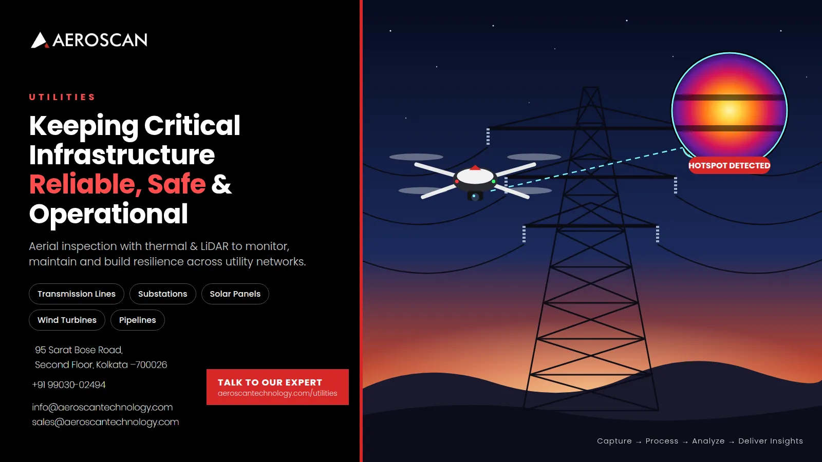

Critical infrastructure rarely gets a second chance. A damaged transmission component, unnoticed pipeline leak, overheating transformer, cracked wind-turbine blade, or weakened section of a dam can turn into a much larger operational problem if it is not identified in time. This is one reason Drone Utility Inspection Solutions are becoming increasingly relevant for companies responsible for power, energy, pipelines, renewable assets, and other utility networks. By combining aerial imaging, thermal sensors, LiDAR, specialised payloads, and geospatial analysis, modern inspection teams can collect detailed information while reducing unnecessary exposure to difficult or hazardous environments.
Why Utility Infrastructure Needs a Different Kind of Inspection
Utility networks are spread across large geographical areas.
Transmission lines can cross forests, agricultural land, mountains, and remote regions. Pipelines can extend for hundreds of kilometres. Solar farms may contain thousands of panels distributed across large sites. Wind turbines are tall structures where close visual inspection can be difficult. Hydropower facilities can include dams, reservoirs, slopes, and supporting infrastructure.
Inspecting all these assets using only conventional ground-based methods can require considerable time, manpower, equipment, and planning.
There is also the issue of accessibility.
Some assets are located in places where reaching them safely is difficult. Others require specialised equipment or shutdowns before close inspection can take place.
Drone technology provides another option.
Instead of sending inspection teams physically to every difficult location, operators can use aerial platforms to capture high-resolution information from above. This information can then be processed and analysed to identify areas that need closer attention.
Aeroscan's Utilities division focuses specifically on aerial inspection and geospatial intelligence for monitoring, maintenance, and resilience across utility networks.
Moving From Reactive Maintenance to Proactive Inspection
Traditional maintenance strategies often respond to visible faults or scheduled inspection intervals.
The problem is that an asset does not necessarily wait for the next scheduled inspection before developing a problem.
A component may gradually deteriorate. A connection may begin overheating. Corrosion may develop. Vegetation may move into a right-of-way. A pipeline may develop a leak. A solar panel may begin producing less energy because of a damaged cell.
If these issues are identified only after performance is affected, the cost of intervention can be significantly higher.
Aerial inspection supports a more proactive approach.
Regular drone surveys can create a record of asset conditions over time. By comparing newer information with previous surveys, inspection teams can identify changes and prioritise maintenance activities.
This turns inspection from a one-time activity into an ongoing asset-management process.
Transmission Line Inspections from a Safer Perspective
Transmission lines are among the most obvious applications for drone-based infrastructure inspection.
A typical transmission corridor may include towers, conductors, insulators, connections, vegetation, and surrounding land. Inspecting these components manually across a large network can be challenging.
Drones equipped with high-resolution cameras can capture detailed imagery of towers and conductors. This can help identify visible problems such as damaged components, missing parts, corrosion, or other structural abnormalities.
Thermal imaging adds another dimension.
Some electrical faults produce abnormal heat before they become visible through conventional photography. Thermal surveys can therefore help identify overheating components and potential failure points.
LiDAR can also contribute to transmission-line management by providing accurate spatial information. It can support sag analysis and help identify vegetation or other encroachments within rights-of-way.
Aeroscan's utility inspection capabilities combine RGB, LiDAR, and thermal imaging for transmission tower, pole, and conductor inspections.
The result is a more detailed picture of both the asset itself and the environment around it.
Thermal Imaging Makes Invisible Problems Easier to Find
One of the most valuable aspects of modern drone inspection is thermal imaging.
A standard camera records what an object looks like.
A thermal sensor records temperature differences.
That distinction can be extremely important when inspecting electrical or mechanical equipment.
An overheating transformer connection, electrical component, or solar-panel hotspot may not look unusual in a normal photograph. Thermal imagery can highlight the temperature anomaly and direct maintenance teams toward a potential problem.
This is particularly useful because early identification can create an opportunity for intervention before a minor fault becomes a major failure.
Thermal technology is not limited to power infrastructure.
It can also be applied to solar panels, wind turbines, industrial equipment, buildings, and other assets where temperature patterns provide useful information.
Aeroscan's wider geospatial capabilities include thermal inspection for transmission lines, substations, solar panels, wind turbines, equipment, fire detection, and energy-efficiency studies.
Substation Inspections Without Unnecessary Disruption
Substations are critical nodes in electrical networks.
They contain transformers, breakers, connections, and other equipment that must operate reliably. Because substations are concentrated areas containing multiple important components, a problem in one part of the facility can affect wider operations.
Drone inspections can provide detailed visual and thermal information across these assets.
Thermal analysis can help identify overheating transformers, breakers, and connections. Visual imagery can support assessments of structural condition, equipment wear, and other abnormalities.
One important advantage is the ability to collect information efficiently without requiring inspectors to physically approach every component during the initial assessment.
Aeroscan specifically offers thermal and visual substation inspections to support maintenance planning and reduce the likelihood of unexpected downtime.
This creates an opportunity to prioritise maintenance based on actual asset conditions rather than treating every component identically.
Pipeline Monitoring Requires Continuous Awareness
Pipelines are another major area where aerial inspection can provide value.
Oil, gas, and water pipelines can extend through difficult terrain and remote locations. Their surrounding rights-of-way also need to be monitored for encroachment, construction activity, environmental changes, and other risks.
A drone can cover large sections of a corridor comparatively quickly while capturing detailed imagery.
But visual inspection is only part of the story.
Specialised sensors can provide additional information.
Methane sensors, for example, can help identify potential gas leaks. Thermal imaging can contribute to detecting anomalies, while high-resolution imagery can support identification of corrosion, cracks, or structural vulnerabilities.
Aeroscan's utility offering combines drone-based pipeline monitoring with methane sensors and thermal imaging, along with right-of-way monitoring.
This makes drone technology useful not only for checking the physical pipeline but also for monitoring the environment surrounding it.
Solar Farms Need More Than a Visual Check
Solar energy has expanded rapidly, creating large installations containing thousands of individual panels.
Even a relatively small performance problem across many panels can affect total energy generation.
The challenge is finding the affected panels.
Walking through a large solar farm and manually inspecting every panel can be time-consuming. Thermal drone surveys can provide a faster way to scan large areas and identify abnormal heat patterns.
Hotspots may indicate damaged cells or other issues requiring further investigation.
High-resolution imagery can also help identify physical damage, dirt accumulation, structural issues, and other visible conditions.
Aeroscan's solar inspection capabilities combine thermal and high-resolution inspection to identify hotspots, damaged cells, dirt accumulation, and structural problems while supporting maintenance and energy-output optimisation.
For solar operators, this means inspection data can become part of a broader performance-management strategy rather than simply a periodic maintenance exercise.
Wind Turbine Inspection from the Air
Wind turbines are designed to operate in demanding environmental conditions.
Their blades experience repeated mechanical loads, wind exposure, temperature changes, and weather-related wear. Over time, cracks, erosion, and other forms of deterioration can develop.
Inspecting turbine blades and towers can be difficult because of their height and design.
Drone technology provides a practical aerial perspective.
High-resolution cameras can capture detailed imagery of blades, nacelles, and towers. Thermal analysis can add information about abnormal heat conditions in relevant components.
Aerial inspection can therefore help maintenance teams determine whether closer physical inspection is necessary and where attention should be focused.
Aeroscan's utility capabilities include inspection of wind-turbine blades, nacelles, and towers for cracks, erosion, and wear, supported by thermal analysis for overheating components.
This can help operators identify developing issues before they contribute to an unexpected failure.
Hydropower Infrastructure Has Its Own Challenges
Hydropower facilities combine multiple infrastructure types.
Dams, surrounding slopes, water bodies, access areas, and supporting structures all need to be monitored.
Some problems can be difficult to observe from ground level.
Drone surveys can provide aerial views of large sections of the facility, helping teams identify cracks, seepage indicators, vegetation overgrowth, and erosion risks.
Aerial data can also contribute to understanding water flow and sediment conditions.
Aeroscan's hydropower monitoring capability uses aerial surveys to assess dams and associated infrastructure, while water-flow and sediment analysis can support operational efficiency and long-term structural stability.
For infrastructure managers, the benefit lies in having a broader picture of the facility instead of examining isolated components without their surrounding context.
Energy Efficiency Is Not Only About Power Generation
Utility-related inspection also extends into buildings.
Energy loss from poorly insulated walls, roofs, windows, or other building components can increase operating costs.
The challenge is that heat loss is not always visible.
Thermal imaging can reveal temperature differences across a building envelope and highlight areas where heat is escaping or insulation may be inadequate.
This information can then support decisions about maintenance, insulation improvements, and energy-efficiency upgrades.
Aeroscan provides thermal inspection for residential, commercial, and industrial buildings to identify heat loss and insulation gaps.
The same technology that helps identify overheating electrical components can therefore also contribute to reducing unnecessary energy consumption.
Disaster Response Requires Speed
Utility infrastructure becomes particularly vulnerable during extreme events.
Floods can damage substations and pipelines. Storms can affect transmission lines. Earthquakes can disrupt multiple infrastructure systems simultaneously.
After a disaster, operators need information quickly.
Where is the damage?
Which assets are still operational?
Which areas are inaccessible?
Where should maintenance teams go first?
Aerial surveys can help answer these questions without requiring inspection teams to physically enter every affected location immediately.
Drones can capture imagery of damaged areas, helping organisations understand the scale and distribution of the problem.
Aeroscan includes rapid post-disaster surveys for utility networks affected by floods, storms, and earthquakes, supporting damage assessment and recovery planning.
This is particularly important because recovery decisions often need to be made under difficult conditions and limited information.
The Importance of LiDAR in Utility Mapping
LiDAR is another important technology in modern utility inspection.
Unlike conventional photography, LiDAR uses laser pulses to measure distances and create highly detailed three-dimensional representations of terrain and structures.
This makes it particularly useful for corridors and infrastructure where elevation, vegetation, and spatial relationships matter.
For transmission lines, LiDAR can support right-of-way analysis and sag assessment.
For other infrastructure projects, it can contribute to terrain mapping, 3D modelling, vegetation analysis, and corridor management.
Aeroscan's broader LiDAR capabilities include corridor and right-of-way mapping, terrain modelling, vegetation penetration, and hydrology and erosion studies.
The value of LiDAR becomes especially apparent when utility managers need accurate spatial information rather than simple photographs.
Data Is Only Valuable When It Becomes Actionable
A large collection of drone photographs does not automatically solve an infrastructure problem.
The real objective is to convert raw information into useful findings.
This requires a structured workflow.
Aeroscan describes its utility workflow as:
Capture → Process → Analyze → Deliver Insights
The drone and sensor data is converted into inspection reports, maps, and actionable outputs aligned with utility operations and safety requirements.
This distinction matters.
An inspection team does not simply need thousands of photographs. It needs to know which asset requires attention, what type of anomaly has been identified, where it is located, and how urgently it should be investigated.
Good data processing and analysis therefore become just as important as the flight itself.
AI Can Make Large Inspection Datasets More Manageable
Modern utility networks can generate enormous amounts of inspection information.
Manually reviewing every image can become inefficient when surveys are repeated frequently or cover extensive infrastructure.
AI-assisted analysis can help automate parts of this process.
Computer-vision systems can be used to identify patterns, detect anomalies, and flag assets that require human review.
Aeroscan's broader technology stack includes AI-assisted analysis for automated feature and anomaly detection, fault identification in assets, and predictive insights based on historical datasets.
The purpose is not to remove human expertise from the inspection process.
Instead, AI can help inspectors focus their attention on the area’s most likely to require action.
This can make large-scale inspection programs more practical and consistent.
Creating a Digital Record of Asset Condition
Another major benefit of repeated drone surveys is historical comparison.
Imagine inspecting the same transmission corridor every six months.
The first survey establishes a baseline.
The next survey can be compared with that baseline.
Over time, changes become easier to identify.
The same principle can apply to solar farms, pipelines, wind turbines, substations, dams, and other infrastructure.
This historical information can support lifecycle planning.
Rather than asking only, "Is this asset damaged today?" maintenance teams can begin asking, "How has this asset changed over the last year?"
That shift can make infrastructure management more predictive.
Improving Safety for Inspection Teams
Safety is one of the strongest arguments for using drones around critical infrastructure.
Inspectors may otherwise need to work near electrical equipment, climb structures, enter difficult terrain, approach industrial assets, or operate in areas affected by environmental hazards.
Drone-based preliminary inspection can reduce the number of situations where people need to physically approach an asset simply to determine whether a problem exists.
If aerial data identifies a specific issue, the maintenance team can then prepare the appropriate equipment and safety procedures before visiting the location.
Aeroscan highlights reduced reliance on manual inspections and improved safety for maintenance and inspection teams among the key benefits of its utility solutions.
In other words, drones do not merely make inspection faster; they can help make inspection planning more informed.
What Utility Operators Should Look for in a Drone Inspection Partner
Not every drone inspection project has the same requirements.
The right solution depends on the asset, terrain, inspection objective, required accuracy, sensor type, and final output.
A utility operator should therefore look beyond the drone itself.
Important considerations include:
- Appropriate RGB, thermal, LiDAR, or specialised sensors
- Experienced drone pilots and technical teams
- Reliable data-processing capabilities
- GIS and geospatial analysis
- Clear inspection reports
- Historical comparison and change detection
- Understanding of infrastructure-specific risks
- Safety and regulatory compliance
- Ability to handle large and complex datasets
Aeroscan's broader capabilities combine drone platforms, advanced sensors, GIS processing, AI-assisted analysis, and end-to-end data delivery across different industries.
This type of integrated approach can be more useful than treating drone flight as a standalone service.
The Future of Utility Inspection Is Becoming More Intelligent
Utility infrastructure will continue to grow more complex.
At the same time, operators are under pressure to improve reliability, control maintenance costs, reduce downtime, and maintain safety.
Drone technology can contribute to all of these objectives by making infrastructure more visible.
A transmission line can be inspected from the air.
A pipeline corridor can be monitored over long distances.
A solar farm can be scanned for thermal anomalies.
A wind turbine can be examined without immediately sending a team up the structure.
A damaged utility network can be assessed quickly after a disaster.
The common factor is better information.
As drone sensors become more capable and AI-based analysis becomes more sophisticated, inspection programs are likely to become increasingly automated, frequent, and data-driven.
The most valuable systems will not simply collect more information. They will help organisations understand what that information means and what action should come next.
Conclusion
Critical infrastructure requires constant attention because small defects can eventually become expensive failures. Drone-based inspection offers utility operators a safer and more efficient way to understand the condition of transmission lines, substations, pipelines, solar installations, wind turbines, hydropower facilities, and other important assets. By combining high-resolution RGB imagery, thermal analysis, LiDAR, specialised sensors, GIS processing, and AI-assisted analytics, modern inspection programs can move beyond periodic visual checks toward continuous, evidence-based asset management. Aeroscan's approach of capturing, processing, analysing, and delivering actionable outputs demonstrates how aerial intelligence can become part of a wider maintenance and resilience strategy. As utilities continue to adopt smarter technologies, Infrastructure Monitoring Services can help organisations detect problems earlier, improve maintenance planning, respond faster to disasters, reduce unnecessary manual inspection, and keep essential infrastructure operating more safely and reliably.




















Sign in to leave a comment.