The commercial real estate landscape is changing rapidly, driven by technology, shifting demographics, and new buyer expectations. For brokers and agents, keeping up with these changes to effectively showcase property potential can be an immense challenge. Properties that once triggered intrigue based on location and appearance alone now require deeper levels of visualization and context. This is where real estate mapping software enters the picture - providing agents with vital tools to illustrate the value of listings in an increasingly visually-driven market.
In this blog post, we'll explore how real estate mapping software is transforming the way brokers promote properties, enabling enhanced pitches, simpler workflows, and increased ROI from listings.
The Problem of Static Listings
Commercial real estate transactions hinge on the ability to identify well-positioned properties and effectively communicate their potential to buyers. Yet even listings in prime locations can be difficult to visualize from palabras and figures alone.
Standard listing marketing materials like brochures and offering memorandums rarely bring properties to life. At best, they include a small static map identifying the general location. Some may also incorporate basic plat maps showing property lines and surroundings. But static maps fail to capture intricate location nuances that dynamic buyers seek, like:
Adjacency to popular retailers, landmarks, and amenitiesAccessibility to highways and transport hubsLocal zoning and development plansArea demographics and traffic patternsSurrounding property valuesProximity to competitorsThese factors heavily influence property valuation and use cases. Without visually highlighting them, buyers lack context to make informed decisions confidently. Many won’t even bother scheduling viewings for listings with minimal location details.
As a result, properties often need to catch up on the market despite favorable attributes, and sellers miss out on optimal deals.
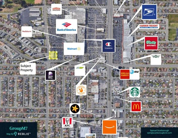
The Visualization Imperative
Modern buyers, especially millennials and younger demographics, expect rich visuals for evaluating opportunities and experiences. Land property maps that dynamically showcase key location traits are now mandatory for commercial real estate marketing. Some key areas where compelling aerial maps provide value:
Enhanced Listing Marketing - Maps that highlight proximity to retailers, parks, transport, landmarks and other amenities pique buyer interest and make listings stand out.Property Valuations - Visualizing surrounding property values, zoning, and development plans assists brokers in accurate pricing and ensures sellers maximize returns.Underwriting Support - Maps highlighting population density and traffic patterns provide vital data for underwriting property loans.Development Planning - Mapping helps planners identify growth opportunities to redevelop or reposition assets.Due Diligence - Maps with zoning, flood areas and neighborhood nuances assist in assessing potential risks.Listing Pitches - Being able to visually walk buyers through an area builds credibility and closes more deals.Turning to Real Estate Mapping Software
Creating dynamic maps tailored for each listing is simply not feasible manually. Scouring sites for photos and logos, locating property markers, editing images in Photoshop, and compiling maps is incredibly time-intensive. This led pioneering brokers to turn to real estate mapping software that could automate map generation tailored for each listing. Rather than static snapshots, they sought tools that allowed buyers to:
Visualize listings relative to local points of interestDynamically explore surrounding amenities and retailersSee intricate location traits at a glanceDigitally immerse themselves in the area prior to site visitsCommercial real estate map solutions like REBLIE now provide these capabilities and so much more, revolutionizing how modern real estate professionals operate.
Final Thoughts
REBLIE stands as a game-changing solution for commercial real estate. Its automated mapping software makes tailored aerial maps effortlessly generated, breathing life into listings within minutes. For dynamic, visually captivating property representations, REBLIE is the ultimate choice. So, look no further next time you need real estate mapping software - go with REBLIE!


Sign in to leave a comment.