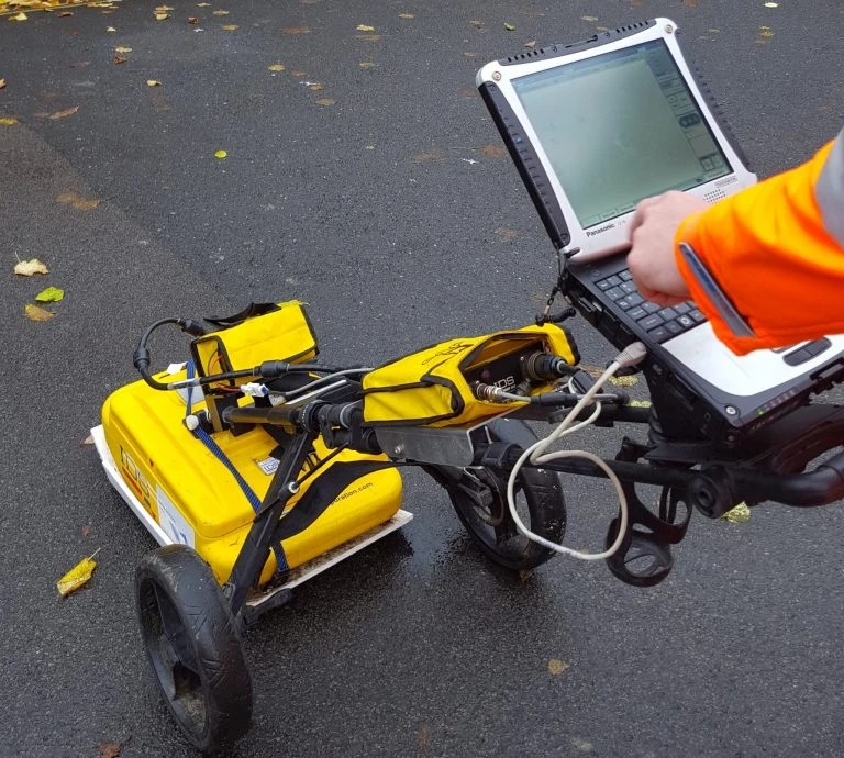
rrWhen it comes to development projects, it’s important for developers to run a GPR survey first. Hence, they call for professional GPR surveyors to handle it for them. For starters, these experts analyse the data they gathered through Ground Penetrating Radar, which can derive information about sub-surface structures that may not be otherwise visible at a surface level due to natural or human activities occurring at or near ground level. This includes archaeological sites, utility lines, pipes, and cables as well as other infrastructure such as roads; all of which are important considerations when undertaking large construction projects in urban areas.rrHere, you will learn the important reasons why you may have to hire GPR surveyors for your project.rrDetect hidden crypts and vaultsrrThere have been many studies done on GPR to conduct surveys on historical floors in old churches. But, first and foremost, KB GPR Surveys would check the building's technical status before doing any research. They want to use Ground Penetrating Radar (GPR) to discover underfloor air gaps, as well as past things and items such as rubble, human bodies, brick walls, and pipes. The GPR technique is particularly helpful for conducting surveys over a big area since it allows the processing of a large amount of data in a short period. In the past, researchers found that the GPR technique worked for imaging reinforcement bars, cracks, flaws in the form of air voids, delamination, and moisture or systems utilized for concrete strengthening.rrGPR is a non-destructive technique that is used by a GPR surveying expert that has been used on historical items for years. GPR is becoming increasingly popular among cultural heritage structures owing to the desire to keep these relics in their original condition for future generations. Because the technical paperwork is incomplete or entirely missing, the exact structure of historical items dating several years back is frequently unknown. In-situ inspection, which is often aided by numerical analyses that give design guidelines and recommendations for planned reconstruction, reinforcement, and restoration work, is a useful technique to gather data in these circumstances.rrInspect bridgesrrThe use of Ground Penetrating Radar (GPR) technology for bridge inspection may be quite beneficial. The technique is especially well-suited for budgeting purposes. This tool of GPR survey agencies produces objective data, whereas acoustical information is subjective. A cart-based system, which includes an antenna and a controller, is typically used to collect data while walking. The radar technology looks for flaws in the returning signal from the reinforcement steel; the more weakened the concrete, the weaker the signal. The technology can reveal the location and depth of rebar, tie bars, and dowel bars.rrUsed for quality assurancerrGPR surveying experts also use GPR for quality assurance/quality control (QA/QC) on a new bridge deck, to ensure that the rebar depth is proper. The top rebar mat should be at the depth range specified in the bridge plans, and concrete cover measurements are generally taken once the bridge deck has been poured to ensure that it is. To obtain data, a ground-coupled antenna is used along one or more profile lines to record the reflection arrival time. The depth of the centre beam's rebar is then measured, as well as the depth of each rebar. Next, a core is cut at one of the rebar locations to determine the depth of each rod. This is input into the computer program that calculates the radar wave velocity, which is subsequently used to compute other rebar depths along the data-collection profile line.rrUsed for utility mappingrrUtility mapping is a technique used to find underground utilities as well as plumbing or wiring. It is an important element of the civil engineering process, allowing for less expensive and time-consuming repair work as well as delays caused by striking utilities. With an accurate utility map, project planners can accurately estimate the costs of any future work. However, utility mapping has its difficulties. The accuracy of records and mapping has long been a challenge for surveyors, as, of course, accurately locating hidden items is a difficult endeavour.rrThe GPR surveying technology of a GPR survey agency is highly precise. It can detect both metallic and non-metallic utilities. Utility mapping surveys are typically done with the help of GPR since it provides fast data acquisition, low operation expenses, and high-resolution pictures. GPR may be used to supplement more sophisticated techniques, such as radio detection, when combined with alternative equipment. Professionals use both GPR and electromagnetic location (EML) to locate and track metallic and non-metallic materials under the earth. Before you seek GPR surveyors for your utility mapping, make sure they use a wide range of methods to discover and map underground utilities to get more accurate results.rrIndeed, hiring GPR surveyors is quite beneficial. From utility mapping to detecting hidden crypts and vaults, they have advanced tools that can provide more accurate results than other methods. This also makes them crucial in construction projects. If these things sound interesting for the project that you are about to start, consider getting a GPR surveyor beforehand.
The Following Are The Reasons Why GPR Surveyors Are Worth Hiring