

Land clearing is the practice of removing trees, bushes, and other vegetation from a piece of land to make it suitable for other uses such as agriculture, development, mining, and infrastructure. While land clearing has contributed to human progress, it has also caused significant environmental damage. However, with the advancement of technology, it is possible to minimize the negative effects of land clearing in New Hampshire and everywhere else and promote sustainable land use practices. This article will explore the role of technology in minimizing the negative effects of land clearing.
● Satellite Imagery and GIS Mapping
The use of geographic information system (GIS) mapping and satellite photography has completely changed how we monitor and regulate land usage. Satellites can be used to track changes in land usage over time and pinpoint regions where land removal is occurring at an alarming rate. GIS mapping allows us to visualize and analyze complex data related to land use, such as soil types, vegetation cover, and topography. By combining these two, it is possible to identify areas that are most vulnerable to the negative effects of land clearing in NH or anywhere and develop targeted strategies to mitigate them.
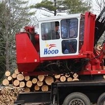
● Mechanical Harvesting and Low-Impact Logging
Mechanical harvesting involves the use of specialized equipment, such as feller-bunchers and skidders, to remove trees with minimal damage to the surrounding vegetation. Low-impact logging is a similar technique that involves careful planning and execution of the harvesting process to minimize damage to the forest floor and soil.
● Forest Restoration and Reforestation
Reforestation and forest restoration are two tactics that can lessen the consequences of removing land. Forest restoration involves the replanting of trees and other vegetation in areas that have been cleared, while reforestation entails planting trees in previously forested areas that have been removed for various purposes. Both strategies can help to restore ecosystem services such as carbon sequestration, soil conservation, and biodiversity, and they can also provide economic benefits such as timber production and ecotourism.
● Remote Sensing and Machine Learning
Remote sensing and machine learning are two technologies that can improve the efficiency and accuracy of land use monitoring and management. Remote sensing involves the use of sensors such as LiDAR and RADAR to collect data on land use, vegetation cover, and other environmental parameters. Machine learning algorithms can then analyze this data to determine patterns and make predictions about future land use changes. By using remote sensing and machine learning, it is possible to identify areas that are at high risk of negative effects from land clearing in Vermont or anywhere and take proactive measures to mitigate them.
Summing Up
Technology has a significant hand in minimizing the negative effects of land clearing. By adopting the technologies that are mentioned above, we can promote sustainable land use practices that balance human needs with environmental conservation. Therefore, if you are searching for such a sustainable land clearing leading provider, you can refer to BW Timber Harvesting. To know more about them, visit their website- https://bwtimberharvesting.com.