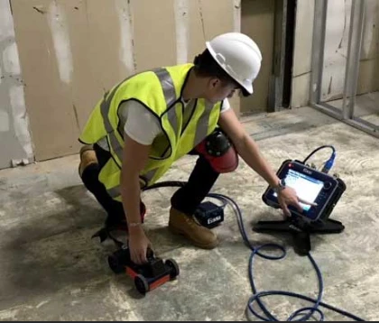
Ground Penetrating Radar Scanning (GPR) is a non-destructive geophysical technique for investigating subsurface materials and structures. It is a high-resolution method that uses electromagnetic waves to detect and map features such as buried utilities, pipes, and geological layers. GPR is widely used in engineering, environmental, and archaeological applications to provide valuable information for project planning and risk assessment.
How does GPR work?
GPR works by transmitting high-frequency electromagnetic waves into the ground and measuring the reflected signals. The waves are then sent through an antenna placed on the surface or buried in the background. When the waves encounter a change in the material properties, such as a boundary between two different layers, some of the energy is reflected to the surface. The reflected signals are then detected by the antenna and recorded by a receiver.
Connect with Concrete Insight, if you are looking for a reliable partner for Ground Penetrating Radar Services in Virginia.
The travel time of the waves and the strength of the reflected signals provide information about the depth, size, and shape of the objects or materials underground. GPR can also be used to measure the dielectric properties of the materials, which can help identify different subsurface features.
What can it detect?
A GPR system can be used to detect a wide variety of items. Here are the following items for which it can be used to see.
Metal,Plastic,PVC,Concrete,Natural materials.Changes in ground strata,Geological features and rock obstructions,Air pockets or voids,Excavated and back-filled areas,Groundwater tables,Bedrock.Importance of GPR
GPR is a valuable tool for many applications because it can provide detailed information about subsurface conditions without excavation or drilling. This non-destructive method can save time and money by reducing the need for invasive testing and site preparation. Some of the most critical applications of GPR include:
Utility Locating: GPR can locate underground utilities such as pipes, cables, and conduits. This information is crucial for excavation and construction projects to avoid damaging these utilities and causing disruptions to services.Environmental Site Assessment: GPR can be used to investigate soil and groundwater contamination by mapping subsurface layers and detecting anomalies. You can use this information to design remediation plans and mitigate risks to human health and the environment.Archaeological Investigations: Ground penetrating radar can map buried structures and artifacts without excavation. This method can help archaeologists identify potential sites and plan future excavations.Geotechnical Investigations: GPR Scanning can be used to investigate subsurface conditions for foundations, tunnels, and other infrastructure projects. The information obtained from GPR can help engineers design safe and stable structures.GPR is an essential tool for project planning, risk assessment, and safety, as it provides valuable information about subsurface conditions without the need for invasive testing or site preparation.


Sign in to leave a comment.