Geophysical survey services refer to a set of techniques and methods used to gather information about the subsurface of the Earth without excavating or drilling. These techniques are used for a wide range of applications, including mineral exploration, environmental assessment, civil engineering, and archaeology. The goal of a geophysical survey is to gather information about the physical properties of the subsurface, such as the composition, structure, and depth of subsurface materials.
One of the most widely used geophysical survey methods is ground-penetrating radar (GPR). GPR works by transmitting radar waves into the subsurface and measuring the reflected signals. These signals can provide information about the composition and structure of subsurface materials, such as rock layers, soil types, and underground utilities. GPR is a non-destructive method, which makes it an ideal tool for a wide range of applications, including environmental assessment, civil engineering, and archaeology.
Another common geophysical survey method is magnetic survey, which measures the natural magnetic fields of the Earth. This method is particularly useful for identifying subsurface features such as buried metal objects, mineral deposits, and even archaeological artifacts. It is also used to locate buried utilities and other subsurface features, like pipes and cables.
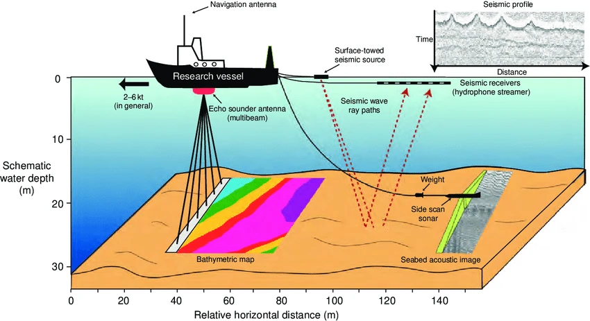
Seismic survey is another widely used geophysical method, it measures the velocity and reflection of seismic waves that travel through the subsurface. This method is often used to map the structure of the subsurface, including rock layers, faults, and underground water resources. It also can be used to locate buried utilities and other subsurface features.
Electrical resistivity survey is a method that measures the electrical resistivity of subsurface materials. This method is particularly useful for identifying subsurface features such as soil types, rock layers, and underground water resources. It is also used to locate buried utilities and other subsurface features.
Each of these geophysical methods has its own advantages and limitations, and the choice of method will depend on the specific application, the type of information required, and the conditions at the survey site. For example, GPR is most effective in dry, sandy soils, while magnetic survey is most effective in areas with a high concentration of metal objects.
In addition to these methods, there are also other geophysical techniques, such as gravity survey, electromagnetic survey, and ground-coupled radar. These methods are used in specific situations and have their own advantages and limitations.
In conclusion, geophysical survey services are a vital tool for understanding the subsurface of the Earth. These techniques use non-destructive methods to gather information about the physical properties of the subsurface, such as the composition, structure, and depth of subsurface materials.
Falcon Survey is provide geophysical survey services in Dubai. Our team of experienced professionals use the latest techniques such as GPR, magnetic survey, seismic survey, and electrical resistivity survey to gather accurate and reliable data. Whether it's for mineral exploration, environmental assessment, civil engineering or archaeology, Falcon Survey is equipped to provide the right service for your specific needs. If you are in need of geophysical survey services in Dubai, don't hesitate to contact Falcon Survey.


Sign in to leave a comment.