
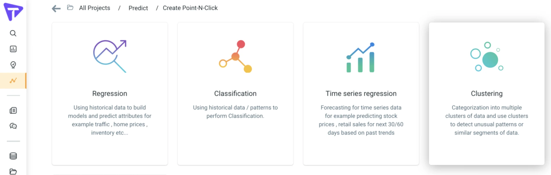
Modern smartphones rely on more than just GPS satellites to pinpoint your location. The LPPe Service (LTE Positioning Protocol Extension) is a system-level component found on many Android devices—especially those using MediaTek chipsets—that enhances location tracking by combining multiple data sources: GPS, cell towers, and Wi‑Fi. This combined approach helps the device deliver faster and more accurate location results, especially in situations where traditional GPS might struggle, and it all runs quietly in the background through the LPPe Service APK.
GPS: The Foundation of Location
GPS (Global Positioning System) is usually the primary method smartphones use for location tracking. It uses signals from satellites to calculate your position. While accurate, GPS signals can be weaker indoors, during bad weather, or in areas with tall buildings, which is where LPPe steps in to help.
Cell Towers: Network-Based Assistance
When GPS is limited or slow to respond, the LPPe Service uses nearby cell towers to estimate your location. The phone measures the signal strength and timing from multiple towers to triangulate a general position. Although not as precise as GPS, this method works well when GPS is obstructed or unavailable—like in elevators, subways, or parking garages.
Wi‑Fi: Precision in Urban Areas
Wi‑Fi positioning is especially useful in urban areas where signals from local routers and public networks are abundant. The LPPe Service scans for nearby Wi‑Fi networks and checks their known geographic locations in a database to estimate your position. This method is often faster than GPS and more accurate indoors, such as in malls or airports.
How LPPe Combines Them
The LPPe Service doesn’t rely on just one method. Instead, it fuses information from GPS, cell towers, and Wi‑Fi simultaneously to deliver the best possible estimate of your location. It also considers signal quality, past movement patterns, and environmental conditions. By doing this, the service improves both the speed and accuracy of location tracking.
This combination is especially valuable for:
- Turn-by-turn navigation
- Emergency location services
- Ride-sharing apps (e.g., Uber, Careem)
- Fitness tracking apps (e.g., Samsung Health, Strava)
When It’s Most Useful
LPPe shines in situations where GPS struggles or needs support:
- Indoors or underground, where satellite signals are weak
- Urban environments with tall buildings that block or bounce signals
- Battery-saving scenarios, where full GPS usage would drain power
Modern smartphones rely on more than just GPS satellites to pinpoint your location. The LPPe Service (LTE Positioning Protocol Extension) is a system-level component found on many Android devices—especially those using MediaTek chipsets—that enhances location tracking by combining multiple data sources: GPS, cell towers, and Wi‑Fi.
This combined approach helps the device deliver faster and more accurate location results, especially in situations where traditional GPS might struggle. Here's how it works:
GPS: The Foundation of Location
GPS (Global Positioning System) is usually the primary method smartphones use for location tracking. It uses signals from satellites to calculate your position. While accurate, GPS signals can be weaker indoors, during bad weather, or in areas with tall buildings, which is where LPPe steps in to help.
Cell Towers: Network-Based Assistance
When GPS is limited or slow to respond, the LPPe Service uses nearby cell towers to estimate your location. The phone measures the signal strength and timing from multiple towers to triangulate a general position. Although not as precise as GPS, this method works well when GPS is obstructed or unavailable—like in elevators, subways, or parking garages.
Wi‑Fi: Precision in Urban Areas
Wi‑Fi positioning is especially useful in urban areas where signals from local routers and public networks are abundant. The LPPe Service scans for nearby Wi‑Fi networks and checks their known geographic locations in a database to estimate your position. This method is often faster than GPS and more accurate indoors, such as in malls or airports.
How LPPe Combines Them
The LPPe Service doesn’t rely on just one method. Instead, it fuses information from GPS, cell towers, and Wi‑Fi simultaneously to deliver the best possible estimate of your location. It also considers signal quality, past movement patterns, and environmental conditions. By doing this, the service improves both the speed and accuracy of location tracking.
This combination is especially valuable for:
- Turn-by-turn navigation
- Emergency location services
- Ride-sharing apps (e.g., Uber, Careem)
- Fitness tracking apps (e.g., Samsung Health, Strava)
When It’s Most Useful
LPPe shines in situations where GPS struggles or needs support:
- Indoors or underground, where satellite signals are weak
- Urban environments with tall buildings that block or bounce signals
- Battery-saving scenarios, where full GPS usage would drain power
Final Thoughts
The LPPe Service is a behind-the-scenes enhancement that helps your phone determine your location faster and more reliably. By intelligently blending GPS with cell tower and Wi‑Fi data, it ensures that location-based apps work smoothly, no matter where you are. Most users never notice it, but its impact on accuracy and performance is significant—especially when you're on the move or in complex environments.


Sign in to leave a comment.