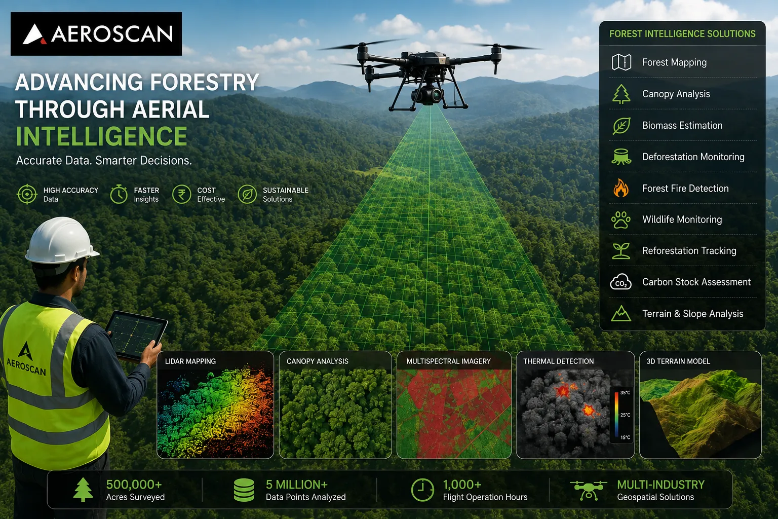

Forests play a critical role in maintaining ecological balance, supporting biodiversity, regulating climate, and protecting natural resources. However, managing large forest landscapes has always been challenging. Traditional surveying methods often require significant manpower, extended fieldwork, and access to remote locations that can be difficult, costly, and time-consuming to monitor.
Today, advanced drone technology is changing how forestry professionals collect and analyse environmental data. The adoption of drone forestry survey India solutions is helping government agencies, environmental organizations, conservation teams, and forestry managers gain accurate insights faster than ever before. By combining UAV technology, LiDAR sensors, thermal imaging, GIS analytics, and AI-powered data processing, forestry operations can become more efficient, sustainable, and data-driven.
Why Forestry Management Needs Better Data
Modern forestry management requires continuous monitoring of forest health, vegetation density, biodiversity, terrain conditions, and environmental changes. Conventional ground surveys often struggle to provide complete visibility across large forest regions.
Drone-based forestry surveys allow organizations to capture detailed aerial data over extensive areas in a fraction of the time required by traditional methods. High-resolution imagery and advanced geospatial analytics help decision-makers identify trends, assess risks, and plan conservation initiatives with greater confidence.
As forests face increasing pressure from climate change, deforestation, wildfires, and land-use changes, accurate and timely information has become more important than ever.
The Growing Role of Drone Technology in Forestry
Drone technology is revolutionizing forest monitoring by providing fast, cost-effective, and highly accurate data collection capabilities. Unlike traditional aerial surveys, drones can operate at lower altitudes while capturing highly detailed information using specialized sensors.
Modern forestry drone surveys utilize technologies such as:
- LiDAR mapping
- RGB aerial imaging
- Multispectral sensors
- Thermal imaging
- GIS-based analysis
- AI-assisted interpretation
These technologies provide forestry professionals with detailed insights into vegetation health, terrain conditions, canopy structure, biomass levels, and environmental changes.
Forest Mapping and Canopy Analysis
One of the most valuable applications of drone forestry surveys is detailed forest mapping.
Using LiDAR and high-resolution imaging systems, drone surveys can generate accurate maps that reveal tree density, canopy coverage, terrain characteristics, and vegetation distribution. Advanced 3D models help forestry managers visualize forest structures more effectively and support long-term planning initiatives.
Accurate forest mapping enables better resource management while reducing the need for extensive manual field surveys.
Supporting Forest Inventory and Biomass Estimation
Forest inventory data plays a crucial role in forestry planning, conservation strategies, and sustainable resource management.
Drone-based LiDAR surveys can estimate tree counts, heights, canopy volume, and biomass with a high degree of accuracy. These measurements help forestry organizations evaluate forest resources, assess timber potential, and support long-term sustainability initiatives.
Accurate biomass estimation is also becoming increasingly important for environmental reporting and carbon management programs.
Monitoring Deforestation and Illegal Logging
Protecting forests requires continuous monitoring of land-use changes and unauthorized activities.
Drone surveys provide an efficient method for identifying deforestation patterns, illegal logging operations, and changes in forest cover. High-resolution aerial imagery allows forestry authorities to detect disturbances quickly and monitor sensitive regions over time.
Early identification of unauthorized activities supports enforcement efforts and helps protect valuable forest ecosystems.
Improving Forest Fire Detection and Prevention
Wildfires remain one of the most significant threats to forests worldwide.
Drone platforms equipped with thermal imaging sensors can identify hotspots and detect fire risks before they develop into major incidents. Real-time aerial monitoring enables forestry teams to assess conditions in remote locations and improve emergency response capabilities.
Faster detection can significantly reduce environmental damage and improve fire management strategies.
Wildlife Monitoring and Habitat Protection
Forests provide essential habitats for countless wildlife species.
Drone surveys equipped with thermal and multispectral sensors help monitor wildlife movement, biodiversity patterns, and habitat conditions without causing significant disturbance. The collected data supports conservation planning, habitat assessment, and biodiversity management programs.
For environmental organizations and conservation agencies, drone technology offers a powerful tool for protecting sensitive ecosystems.
Reforestation and Environmental Restoration
Reforestation projects require continuous monitoring to ensure long-term success.
Drone surveys can track planting progress, evaluate seedling survival rates, monitor vegetation growth, and assess restoration outcomes across large landscapes. This enables project managers to identify challenges early and improve resource allocation.
Data-driven monitoring helps maximize the effectiveness of afforestation and ecological restoration programs.
Carbon Assessment and Sustainability Reporting
As global attention focuses on climate change mitigation, forests are increasingly recognized for their role in carbon sequestration.
Drone-based surveys help estimate forest carbon stocks by measuring biomass, canopy structure, and vegetation density. This information supports environmental assessments, carbon credit programs, sustainability reporting, and climate-related initiatives.
Reliable carbon assessments provide valuable data for organizations working toward sustainability goals.
Why Organizations Are Choosing Aeroscan Technology
Aeroscan Technology provides drone-powered geospatial intelligence solutions for forestry, environmental monitoring, agriculture, infrastructure, mining, and utility sectors. The company combines advanced drone platforms, LiDAR technology, thermal imaging, GIS analytics, and AI-assisted data processing to deliver actionable insights across diverse environments.
Its forestry capabilities include:
- Forest mapping and surveying
- Canopy analysis
- Biomass estimation
- Forest fire monitoring
- Deforestation detection
- Wildlife habitat mapping
- Vegetation analysis
- Reforestation monitoring
- Carbon stock assessment
- Erosion and slope analysis
Aeroscan has surveyed more than 500,000 acres, analysed over 5 million data points, and completed more than 1,000 flight operation hours while supporting organizations across multiple industries.
Conclusion
The future of forestry management depends on accurate, timely, and actionable environmental intelligence.
Drone forestry survey India solutions are enabling organizations to monitor forests more efficiently, protect biodiversity, detect environmental threats, support conservation initiatives, and improve long-term sustainability outcomes. From forest inventory and canopy analysis to wildfire monitoring and carbon assessment, drone technology is becoming an essential tool for modern forestry operations.
By combining advanced UAV technology, LiDAR mapping, AI-powered analytics, and geospatial expertise, Aeroscan Technology helps forestry professionals make informed decisions that support sustainable forest management and environmental stewardship.

























Sign in to leave a comment.