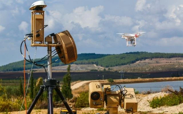

Unauthorized drone incursions against power plants, airports, water treatment facilities, and government installations are escalating at an unprecedented rate. Unauthorized drone activity across critical infrastructure rose by more than 217% in recent years, while drone incidents at European airports surged by as much as 300%. The first quarter of 2025 alone saw more than 400 illegal drone incidents in U.S. airspace. For security directors, procurement officers, and infrastructure operators, drone detection radar has become the essential first line of defense—providing 24/7 airspace monitoring that identifies threats before they reach protected assets.
This guide explains how radar-based drone detection works, why it outperforms other sensor technologies, where it is deployed across critical sectors, and what you should evaluate when selecting a system for your facility. Whether you are assessing counter-UAS (C-UAS) solutions for a single site or designing a multi-layered security architecture across a distributed network, the information here will help you make an informed decision.
The Growing Drone Threat to Critical Infrastructure
The rapid proliferation of commercial and custom-built unmanned aerial vehicles (UAVs) has fundamentally changed the threat landscape for critical infrastructure. Drones are inexpensive, widely available, and capable of carrying payloads ranging from surveillance cameras to explosive devices. What was once considered a nuisance, a recreational quadcopter drifting near a restricted area has evolved into a legitimate operational and national security concern.
Consider the scale of the problem. The FAA continues to receive more than 100 drone sighting reports near airports every month. In 2024, over 350 drone incidents were documented across more than 100 U.S. military installations. High-profile shutdowns at Munich Airport in October 2025 and Copenhagen Airport in September 2025 stranded hundreds of passengers and caused millions in operational losses—triggered by a single unauthorized drone in each case.
Beyond aviation, the energy sector faces mounting exposure. Power generation facilities, substations, pipelines, refineries, and renewable energy installations are geographically distributed, heavily automated, and foundational to economic stability. Drones have already been used to surveil these assets, deliver contraband to correctional facilities, and—in conflict zones—strike fuel storage infrastructure with devastating effect. In March 2026, a series of escalating drone attacks near Dubai International Airport progressed from minor structural damage to fuel tank strikes in just fifteen days, underscoring how quickly drone threats can escalate from surveillance to kinetic action.
The global counter-drone market reflects this urgency. The drone airspace security system market was valued at approximately $1.83 billion in 2025 and is projected to reach $4.58 billion by 2030, growing at a compound annual growth rate (CAGR) of roughly 20%. The U.S. government allocated $693 million for C-UAS capabilities in the FY2026 defense budget and established the Joint Interagency Task Force 401 (JIATF-401) to unify previously fragmented counter-drone programs under a single command structure.
The message is clear: drone threats to critical infrastructure are not theoretical. They are documented, growing, and increasingly sophisticated. Facilities that lack dedicated airspace monitoring are operating with a significant security gap.
How Drone Detection Radar Works
Drone detection radar operates on the same fundamental principle as all radar systems: it transmits radio frequency (RF) energy into the environment and analyzes the signals that reflect back from objects in the coverage area. However, detecting small, low-altitude, slow-moving drones presents unique challenges that require specialized radar architectures and signal processing techniques.
Radar Signal Principles for Drone Detection
When a radar transmits an electromagnetic pulse or continuous wave, any object in the beam path reflects a portion of that energy back toward the receiver. By measuring the time delay between transmission and reception, the radar calculates the target’s range. Analyzing the frequency shift of the return signal, known as the Doppler effect, reveals the target’s velocity and direction of travel. Drones present a particularly small radar cross-section (RCS), often comparable to that of a bird. To distinguish a UAV from environmental clutter such as birds, vehicles, and foliage, advanced drone detection radars analyze micro-Doppler signatures: the unique frequency modulations caused by the high-speed rotation of drone propellers. These micro-Doppler patterns serve as a fingerprint that helps the radar classify an airborne object as a drone rather than a bird or debris.
Types of Radar Used in Drone Detection Systems
Three primary radar technologies dominate the counter-UAS detection landscape, each offering distinct advantages depending on deployment requirements.
Frequency-Modulated Continuous-Wave (FMCW) Radar transmits a continuous signal that sweeps across a range of frequencies. By comparing the transmitted and received frequency at any given moment, FMCW radar simultaneously measures both range and velocity. This technology is highly effective in cluttered environments because it can distinguish moving drones from stationary background objects. FMCW systems are compact, cost-effective, and well-suited for perimeter security applications at individual facilities.
Pulsed Doppler Radar emits short bursts of RF energy and measures the frequency shift in each return pulse. It excels at detecting fast-moving targets and provides reliable performance in electromagnetic interference (EMI) environments. Some advanced pulsed radar systems are naturally resistant to jamming, making them suitable for military and high-security deployments where electronic warfare is a concern.
Phased Array Radar uses multiple antenna elements that electronically steer the radar beam without physically rotating the antenna. This enables extremely fast scan rates, high update frequencies, and the ability to track multiple targets simultaneously across a wide coverage area. Phased array systems are the preferred choice for protecting large critical infrastructure sites, airports, and military bases where 360-degree volumetric coverage and rapid threat assessment are essential.
Detection Range and Accuracy Considerations
The effective detection range of a drone radar system depends on several interrelated factors: the radar’s transmit power, antenna gain, operating frequency, and the radar cross-section of the target drone. Most commercial drone detection radar systems achieve reliable detection of small consumer drones (RCS of approximately 0.01 m²) at ranges between 1 and 5 kilometers, with larger military-grade systems extending coverage beyond 10 km. Some manufacturers report the ability to detect class-1 nano and micro drones, providing early warning at distances sufficient for operators to assess, escalate, and respond before a threat reaches protected assets.
The Small Drone Detection Challenge
The most dangerous drone threats often come from the smallest platforms. Micro and nano drones may weigh less than 250 grams and present a radar cross-section smaller than many common birds. Detecting these targets requires radars with high sensitivity, fast update rates, and AI-enhanced classification algorithms that can differentiate a hovering nano-drone from a perching bird based on micro-Doppler characteristics, flight kinematics, and behavioral patterns. Modern systems increasingly rely on machine learning trained on millions of real-world observations to reduce false alarm rates while maintaining a high probability of detection.
Drone Radar vs. Other Detection Methods
Drone detection radar is not the only technology available for identifying unauthorized UAV activity, but it is widely recognized as the most reliable primary detection layer. Understanding how radar compares to alternative sensor technologies is essential for designing an effective counter-drone architecture.
| Technology | Strengths | Weaknesses | Range | Best For |
| Radar | All-weather, detects dark drones, precise tracking | Higher cost, requires calibration | 1–10+ km | Primary detection layer |
| RF Detection | Identifies drone make/model, locates pilot | Cannot detect dark drones or autonomous UAVs | 1–5 km | Identifying commercial drones |
| EO/IR Camera | Visual confirmation, evidence capture | Limited in fog, rain, darkness without IR | 0.5–3 km | Visual ID and verification |
| Acoustic Sensors | Passive, low power | Short range, affected by ambient noise | 100–500 m | GPS-denied or RF-dense areas |
The critical distinction is that radar detects everything that moves in the airspace, regardless of whether the drone is emitting a control signal. RF detection systems rely on intercepting the communication link between a drone and its operator. When a drone operates autonomously on a pre-programmed flight path—or through fiber-optic tethering—it emits no RF signature and is invisible to RF-only sensors. These so-called “dark drones” represent the most dangerous threat category because they are specifically designed to evade detection, and radar remains the only sensor technology capable of reliably identifying them at operationally relevant distances.
For this reason, most enterprise-grade counter-drone deployments use radar as the backbone of a sensor fusion architecture, combining radar data with RF detection, electro-optical/infrared cameras, and acoustic sensors to achieve comprehensive detection, classification, tracking, and identification across all threat scenarios.
Ready to evaluate drone detection radar for your facility? Request a demo or download our system specification guide to compare solutions side by side.]
Key Applications: Where Drone Detection Radar Is Deployed
Drone detection radar systems are actively protecting critical infrastructure across multiple sectors. The following deployment scenarios illustrate where radar-based airspace security delivers the greatest operational impact.
Airports and Aviation
Unauthorized drones near airports pose immediate safety risks, including potential collisions with manned aircraft and costly runway closures. Airport drone detection radar systems provide continuous low-altitude airspace surveillance around runways, taxiways, and approach corridors. When integrated with air traffic management systems, they give controllers real-time situational awareness to initiate holding patterns or diversions before an incursion becomes a collision risk. With the 2026 FIFA World Cup approaching, stadium and airport security planning has accelerated the deployment of layered detection systems combining radar, RF, and high-zoom cameras.
Power Grids and Energy Utilities
Power generation stations, substations, transmission lines, and renewable energy farms are geographically dispersed and often located in remote areas with limited on-site security personnel. Drone detection radar provides automated 24/7 airspace monitoring that can alert control centers to unauthorized UAV activity without requiring continuous human observation. In the energy sector, radar integration with existing SCADA (Supervisory Control and Data Acquisition) systems enables automated lockdown procedures when a drone threat is confirmed within a defined perimeter.
Water Treatment and Municipal Utilities
Water treatment plants, pumping stations, and reservoir systems are classified as critical infrastructure under federal guidelines. These facilities are vulnerable to drone-based surveillance that could reveal operational vulnerabilities, as well as to potential payload delivery targeting exposed chemical storage or processing equipment. Radar-based detection systems provide the early warning capability needed to initiate security protocols before a drone reaches sensitive areas of the facility.
Data Centers and Telecommunications
Data centers house the digital backbone of modern commerce and communications. A drone equipped with a signals intelligence payload could intercept wireless emissions, while a kinetic attack on exposed cooling systems or power infrastructure could cause cascading service outages. Perimeter security radar integrated with video management systems (VMS) provides automated drone detection and tracking, allowing security teams to visually confirm threats and coordinate response actions from a centralized command center.
Government and Military Installations
Military bases, government buildings, diplomatic compounds, and correctional facilities face drone threats ranging from intelligence collection to contraband delivery and direct attack. In correctional settings, drug cartels have been documented using consumer drones costing as little as $1,000 to deliver drugs and phones into secured facilities. Military installations require counter-UAS radar capable of operating in contested electromagnetic environments, tracking drone swarms, and integrating with kinetic and non-kinetic mitigation systems. The establishment of JIATF-401 under the NDAA FY2026 signals a unified approach to defending U.S. military sites from the growing UAV threat.
Integration with Existing Security Infrastructure
A drone detection radar system delivers the greatest value when it operates as part of a connected security ecosystem rather than as a standalone sensor. Modern counter-UAS platforms are designed for seamless integration with the technologies and workflows already in place at critical infrastructure sites.
Video Management System (VMS) Integration. When radar detects and tracks an airborne target, it can automatically cue pan-tilt-zoom (PTZ) cameras to slew toward the threat, providing visual confirmation without manual intervention. This radar-to-camera handoff reduces response time from minutes to seconds and ensures security operators receive both positional data and live video in a single unified display.
SCADA and Industrial Control System Integration. For energy, water, and manufacturing facilities, radar alerts can trigger automated protective actions through SCADA interfaces—such as shutting down exposed processes, activating physical barriers, or transitioning sensitive equipment to a safe state. API-based integration and standard protocols such as ONVIF and MQTT enable radar data to flow into existing operational technology (OT) networks.
Perimeter Intrusion Detection System (PIDS) Integration. Drone detection radar extends the traditional ground-based perimeter into the airspace above a facility. By integrating radar tracks with PIDS data, security teams gain a unified common operating picture that covers both terrestrial and aerial threat vectors from a single command interface.
Command and Control (C2) Platforms. AI-powered C2 software platforms—such as Dedrone’s DedroneTracker, DroneShield’s DroneSentry, or Anduril’s Lattice—fuse inputs from radar, RF sensors, cameras, and acoustic detectors into a single real-time display. These platforms apply machine learning to classify threats, filter false alarms, and recommend or automate response actions. The result is a sensor fusion architecture where radar provides the primary wide-area detection layer and other sensors contribute identification, classification, and forensic intelligence.
Regulatory and Legal Framework for Drone Detection Radar
Deploying drone detection radar involves navigating a complex regulatory landscape that varies by jurisdiction, facility type, and the specific capabilities of the system being deployed. Understanding these requirements is critical for ensuring legal compliance and avoiding unintended interference with authorized airspace operations.
FAA Airspace Regulations. The Federal Aviation Administration governs all operations within the National Airspace System (NAS). While passive detection (monitoring the airspace for unauthorized drones) is generally permissible, active countermeasures such as jamming, spoofing, or kinetic interdiction are restricted to authorized federal agencies under current law. Facility operators can detect, track, and report drone incursions, but most cannot legally disable or intercept a drone without federal authorization.
FCC Equipment Authorization. Radar systems that transmit RF energy must comply with FCC Part 15 regulations or hold specific equipment authorizations. Most commercial drone detection radars operate within allocated frequency bands and are designed to meet FCC requirements out of the box, but procurement teams should verify certification status before deployment.
CISA Guidelines and Executive Orders. Following Executive Order 14305, “Restoring American Airspace Sovereignty,” CISA published the Be Air Aware™ suite of security guides in November 2025 to help organizations detect, respond to, and manage UAS threats. These guidelines provide a framework for critical infrastructure operators to assess their drone risk posture and implement appropriate detection and response protocols.
Department of Defense C-UAS Authority. Under the NDAA FY2026, the Department of Defense expanded its authority to operate counter-drone systems over U.S. territory for scenarios including border security, VIP protection, and critical infrastructure defense. The creation of JIATF-401 consolidated previously fragmented C-UAS programs into a unified joint command, signaling a significant institutional commitment to countering the domestic drone threat.
State-Level Considerations. Several states have enacted or proposed legislation addressing drone operations near critical infrastructure, including enhanced penalties for unauthorized overflight and expanded authority for facility operators to deploy detection systems. Procurement teams should review applicable state statutes alongside federal requirements to ensure full compliance.
Choosing the Right Drone Detection Radar System
Selecting a drone detection radar requires careful evaluation of operational requirements, environmental conditions, and integration needs. The following criteria should guide the assessment process.
Detection Range and Sensitivity. Determine the minimum detection range needed to provide adequate response time based on your facility’s security protocols. A system that detects a consumer drone at 3 km provides significantly more reaction time than one that detects at 500 meters. Also evaluate sensitivity against small targets—can the radar reliably detect nano and micro drones (class 1 UAVs)?
Coverage Volume and Geometry. Assess whether you need 360-degree azimuthal coverage, elevated angle coverage (to detect steep-angle attacks from above), or sectoral coverage focused on specific approach corridors. Some facilities benefit from 3D dome coverage that protects against threats from all directions, including directly overhead.
Environment and Clutter. Urban deployments, coastal installations, and sites near highways or rail lines present high-clutter environments where the radar must distinguish drones from vehicles, marine vessels, birds, and other moving objects. Evaluate the system’s clutter rejection capabilities and false alarm rate in conditions representative of your site.
Fixed vs. Mobile Deployment. Permanent installations at fixed sites require different solutions than mobile or rapid-deployment scenarios such as temporary event security, military forward operating bases, or emergency response operations. Mobile systems should offer setup times measured in minutes, not hours.
Integration Capabilities. Verify that the radar system supports open APIs, standard communication protocols, and compatibility with your existing VMS, SCADA, and security management platforms. Proprietary ecosystems that lock you into a single vendor’s product suite limit future flexibility and increase long-term costs.
Scalability and Future-Proofing. As drone threats evolve, your detection system must be capable of software updates that improve classification accuracy, add new drone signatures to its threat library, and adapt to emerging tactics. Look for systems with over-the-air update capabilities and active manufacturer investment in AI and machine learning development.
Vendor Evaluation Checklist. Request documented performance data from controlled testing environments. Ask for references from deployments in similar infrastructure sectors. Verify regulatory certifications (FCC, CE). Confirm warranty, maintenance, and support terms. Evaluate total cost of ownership, including installation, licensing, updates, and training—not just the hardware acquisition price.
Frequently Asked Questions About Drone Detection Radar
How does drone detection radar work?
Drone detection radar transmits radio frequency energy and analyzes the signals reflected by airborne objects. It measures a target’s range, speed, and direction using time-delay and Doppler frequency analysis. Advanced systems use micro-Doppler signatures—created by spinning propellers to classify objects as drones rather than birds or other airborne clutter.
What is the range of a drone detection radar system?
Most commercial drone detection radars reliably detect small consumer drones at ranges of 1 to 5 kilometers. Military-grade and large-scale infrastructure systems can extend detection beyond 10 km depending on the radar’s power, antenna design, and the target drone’s radar cross-section.
Can drone radar detect small drones?
Yes. Modern drone detection radars are specifically engineered to detect class-1 UAVs, including nano and micro drones with radar cross-sections comparable to small birds. AI-powered classification algorithms analyze micro-Doppler patterns and flight kinematics to distinguish small drones from environmental clutter.
What critical infrastructure is most vulnerable to drone attacks?
Airports, power plants, electrical substations, water treatment facilities, data centers, oil and gas refineries, telecommunications towers, and military installations are considered the most vulnerable. Any facility where an unauthorized drone could cause operational disruption, safety hazards, or intelligence compromise should evaluate airspace security measures.
Is drone detection radar legal in the United States?
Passive drone detection using radar is generally legal for private and commercial entities. However, active countermeasures such as jamming or intercepting drones are currently restricted to authorized federal agencies. Facility operators should deploy detection and tracking systems while coordinating with law enforcement for interdiction. Radar equipment must comply with FCC Part 15 or hold specific equipment authorization.
How much does a drone detection system cost?
Pricing varies significantly based on range, coverage area, sensor configuration, and integration requirements. Entry-level radar-only systems for single-site perimeter protection may start in the tens of thousands of dollars, while comprehensive multi-sensor C-UAS platforms for large critical infrastructure sites can reach into the hundreds of thousands or more. Total cost of ownership should include installation, software licensing, maintenance, training, and ongoing updates.
What is the difference between drone detection and drone mitigation?
Drone detection refers to identifying and tracking unauthorized drones in the airspace. Drone mitigation refers to the actions taken to neutralize or remove the threat—which may include RF jamming, GPS spoofing, cyber takeover, net capture, or kinetic interception. Detection must occur before mitigation, and radar is the most widely used technology for the detection layer. In the United States, mitigation actions are legally restricted to authorized federal entities.
Protect Your Airspace Before the Next Incursion
The drone threat to critical infrastructure is not a future risk—it is a present reality, documented by escalating incident reports, expanding government budgets, and the hard lessons of facilities that discovered their vulnerabilities only after an incursion occurred. Drone detection radar provides the foundational sensing layer that every serious airspace security architecture requires: reliable, all-weather, 24/7 detection of both commercial and dark drones at operationally relevant distances.
Deploying radar-based detection is not simply a security upgrade. It is a strategic investment in operational continuity, regulatory compliance, and the safety of personnel and communities that depend on critical infrastructure to function without disruption.
Take the next step. Request a drone detection radar demo, download our system specification comparison guide, or contact our security solutions team to schedule a site assessment for your facility.






















Sign in to leave a comment.