I. Introduction
The security and effectiveness of navigation routes have become of utmost importance as the globe grows more connected and dependent on maritime trade. The reliability of nautical charts, the safety of ships, and the sustainability of marine ecosystems are all dependent on hydrographic survey services, which are frequently referred to as the unsung heroes of maritime infrastructure. The importance, methods, and developments that are influencing the future of this crucial marine discipline will all be thoroughly examined in this article as we go deep into the world of hydrographic survey services.
II. Knowledge of Hydrographic Surveys
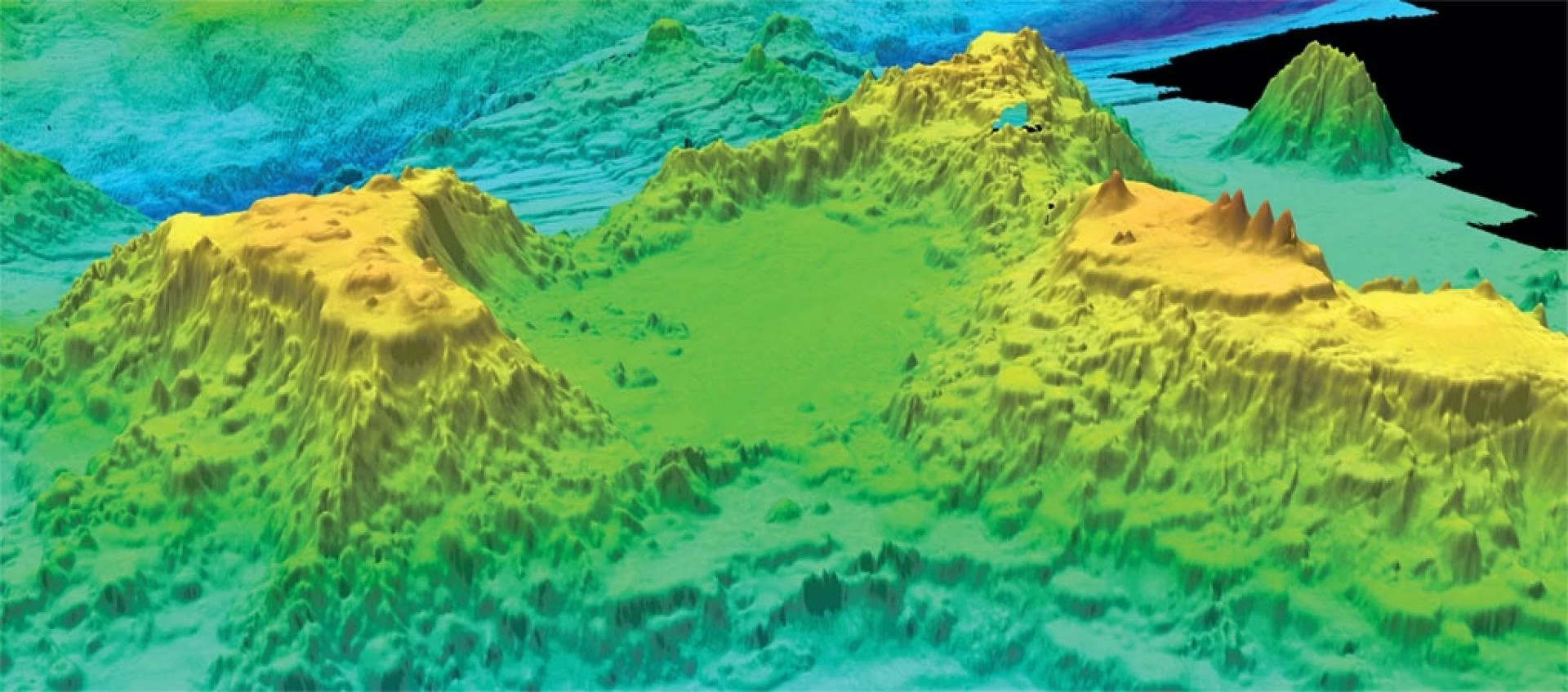
The physical characteristics of bodies of water are measured, described, and mapped by hydrographic surveys, which are scientific investigations. These surveys serve a variety of purposes, from ensuring safe vessel navigation to supporting resource management for the marine industry and creative environmental protection. Hydrographic surveyors employ specialized gear and cutting-edge technologies to collect data on the size, depth, and properties of the ocean floor, riverbeds, and other water bodies.
III. Hydrographic Survey Services: Their Importance
Marine Navigation: Accurate nautical charts are a crucial component of safe marine navigation. Ships can avoid underwater risks and obstacles by using the data from hydrographic surveys to create and maintain current charts. In addition to preventing accidents, this lowers the chances of collisions and groundings.Water depths & Bottom conditions: Planning and building marine infrastructure, such as ports, harbors, and buildings for coastal protection, require hydrographic surveys. These structures are carefully positioned and made to withstand natural forces thanks to precise information on water depths and bottom conditions.
Environmental protection: By better comprehending the properties of water bodies and their ecosystems, these surveys aid in environmental protection. For successful environmental management, habitat protection, and sustainable resource use, this information is crucial.
Oil & Gas: Hydrographic surveys aid in the discovery and utilization of submerged resources such as minerals, oil, and gas. Planning extraction procedures, recognizing prospective reserves, and reducing environmental impacts all benefit from accurate data.
Scientific Research: Oceanography, geology, and marine biology are just a few of the fields where hydrographic data is useful. It aids in the understanding of marine species distribution, underwater geology, and ocean dynamics.
IV. Technology and Methodologies
Data gathering, processing, and fieldwork are all components of hydrographic surveys. Modern hydrographic survey techniques use cutting-edge tools like:
Multibeam Sonar: Multibeam sonar systems send out sound waves that bounce off the ocean floor and return information about the water's depths, the characteristics of the seabed, and even whether wrecks or other debris are present.Single Beam Echosounders: These tools measure the depth of the sea directly beneath the survey vessel using sound waves. They are quite effective for large-scale surveys while being less precise than multibeam systems.
Lidar (Light Detection and Ranging): Lidar (Light Detection and Ranging) systems mounted on aircraft employ laser beams to produce extremely precise elevation models of riverbanks and coastlines, which are useful for mapping shallow seas and coastal areas.
Remote sensing technology: Remote sensing technology, such as satellite and aerial imagery, offer a more comprehensive perspective of huge bodies of water, enabling the identification of broad trends and patterns.
V. Developments and Obstacles
Hydrographic survey services have recently advanced thanks to the combination of automation, machine learning, and artificial intelligence. Faster data processing, greater precision, and the capacity to recognize minute changes in the marine environment are all made possible by these technologies.
The size and abrasiveness of marine habitats, the requirement for ongoing revisions to account for shifting coasts, and international collaboration to maintain borderless navigation remain obstacles.
Conclusion
Hydrographic survey services are still crucial in a world where marine trade and exploration are developing. These services support environmentally friendly resource management, safe navigation, and scientific research while also advancing infrastructure. Our oceans and streams will continue to serve as conduits for connectedness, wealth, and scientific discovery as hydrographic surveys advance in accuracy, efficiency, and environmental sensitivity.


Sign in to leave a comment.