Traditional as-built documentation has long been a pain point for architects, engineers, and construction professionals. Manual measurements, hand-drawn sketches, and time-consuming site visits often result in inaccurate records that fail to capture the true state of completed structures. These outdated methods can lead to costly errors, project delays, and frustrated stakeholders.
Point cloud modeling are revolutionizing this critical aspect of construction and facility management. By capturing millions of precise data points in three-dimensional space, this technology creates highly accurate digital representations of existing structures. The result? As-built documentation that's faster to produce, more comprehensive, and significantly more reliable than traditional methods.
Whether you're managing a historic renovation, planning facility upgrades, or ensuring regulatory compliance, understanding how point cloud modeling services can enhance your as-built documentation process is essential for staying competitive in modern construction and engineering.
What is Point Cloud Modeling?
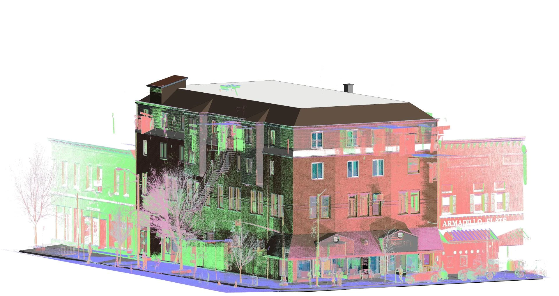
Point cloud modeling is a cutting-edge technology that uses advanced scanning equipment to capture the exact geometry of physical structures. At its core, the process involves collecting millions of individual data points that represent the surface of objects, buildings, or entire sites.
The technology relies primarily on laser scanning devices, also known as LiDAR (Light Detection and Ranging) scanners. These sophisticated instruments emit laser beams that bounce off surfaces and return to the scanner, allowing it to calculate precise distances and create detailed 3D coordinates for each point.
Types of Scanning Equipment
Terrestrial Laser Scanners are the workhorses of indoor and close-range outdoor scanning. These stationary devices can capture incredibly detailed measurements of building interiors, facades, and smaller structures with millimeter-level accuracy.
Mobile Scanning Systems mount laser scanners on vehicles or handheld devices, making them perfect for capturing large areas like roadways, bridges, or entire building complexes quickly and efficiently.
Aerial Scanning Platforms use drones or aircraft equipped with LiDAR sensors to survey large sites, rooftops, or areas that are difficult to access from ground level.
Data Processing and Modeling
Raw point cloud data consists of millions of individual coordinates that must be processed and organized. Specialized software converts this data into usable 3D models, CAD drawings, or Building Information Models (BIM). The processing stage involves cleaning the data, removing noise, and organizing points into coherent representations of the scanned environment.
Benefits for As-Built Documentation
Point cloud modeling services offer substantial advantages over traditional documentation methods, transforming how professionals approach as-built surveys and record-keeping.
Unmatched Accuracy
Traditional measurement techniques typically achieve accuracy within several centimeters at best. Point cloud scanning delivers millimeter-level precision across entire structures. This exceptional accuracy eliminates guesswork and reduces the risk of costly mistakes during renovation or expansion projects.
The comprehensive nature of point cloud data means nothing gets overlooked. Every pipe, beam, fixture, and architectural detail is captured in its exact location and orientation. This level of detail proves invaluable when planning modifications or troubleshooting existing systems.
Dramatic Time Savings
Manual as-built surveys can take weeks or even months for complex structures. Point cloud scanning typically completes data collection in a fraction of that time. A skilled team can scan an entire building in days rather than weeks, while post-processing and model creation add only additional days to the timeline.
The speed advantage becomes even more pronounced for large or complex projects. Industrial facilities, hospitals, and multi-story commercial buildings that would require extensive scaffolding and multiple site visits can be comprehensively documented in a single scanning campaign.
Enhanced Cost-Effectiveness
While point cloud modeling services require an initial investment in technology and expertise, the long-term cost benefits are substantial. Reduced field time means lower labor costs and minimal disruption to ongoing operations. The accuracy of point cloud data also prevents expensive rework caused by measurement errors.
For projects requiring multiple trades or phases, having accurate as-built documentation from the start eliminates redundant surveys and measurements. Each contractor can work from the same precise dataset, improving coordination and reducing conflicts.
Comprehensive Data Capture
Point cloud models capture information that would be impossible or impractical to document manually. Hidden structural elements become visible through the point cloud data. Complex geometries, irregular surfaces, and intricate mechanical systems are recorded with complete fidelity.
This comprehensive approach proves particularly valuable for historic buildings or unique architectural features that don't conform to standard measurement techniques. The resulting documentation preserves these details for future reference and analysis.
Implementation Process
Successfully implementing point cloud modeling services for as-built documentation involves several critical steps that ensure optimal results and maximum value from the investment.
Project Planning and Scope Definition
The implementation process begins with thorough project planning. Professional scanning teams work with clients to define project objectives, identify critical areas for documentation, and establish accuracy requirements. This planning phase determines the appropriate scanning methodology and equipment selection.
Site conditions play a crucial role in planning. Factors such as lighting, accessibility, safety requirements, and operational constraints all influence the scanning approach. Professional point cloud modeling services like those offered by Chudasama Outsourcing bring extensive experience in managing these variables effectively.
Data Collection and Quality Control
The scanning phase requires systematic data collection to ensure complete coverage without gaps or shadows. Professional technicians position scanners strategically throughout the site, often requiring multiple setups to capture all necessary details.
Quality control measures during collection include real-time data verification, overlap checking between scan positions, and immediate identification of any areas requiring additional coverage. This proactive approach prevents the need for return visits and ensures comprehensive documentation.
Processing and Deliverable Creation
Raw point cloud data undergoes extensive processing to create usable deliverables. This stage involves data registration (combining multiple scans into a single coordinate system), noise removal, and format conversion to meet client specifications.
Deliverables can include various formats depending on project needs: traditional CAD drawings, 3D models, BIM files, or web-based viewers that allow stakeholders to explore the point cloud data directly. Professional services providers work closely with clients to determine the most appropriate deliverable formats for their specific workflows.
Integration with Existing Systems
Modern as-built documentation must integrate seamlessly with existing project management and design systems. Point cloud data can be imported into most major CAD and BIM platforms, allowing design teams to work directly with accurate as-built conditions.
The integration process often involves data format conversion, coordinate system alignment, and optimization for specific software platforms. Experienced providers ensure that delivered data works smoothly within client workflows without requiring extensive additional processing.
Future-Proofing Your Documentation Strategy
Point cloud modeling represents more than just an improvement over traditional methods—it's a fundamental shift toward data-rich, digital documentation that supports modern construction and facility management practices.
The technology continues to evolve rapidly, with improvements in scanning speed, accuracy, and processing capabilities emerging regularly. Organizations that adopt point cloud modeling services now position themselves to take advantage of future innovations in construction technology, digital twins, and automated design processes.
As Building Information Modeling (BIM) becomes increasingly standard across the industry, having accurate as-built data in point cloud format provides the foundation for comprehensive digital building models. These models support ongoing facility management, future renovations, and regulatory compliance throughout a structure's lifecycle.
Point cloud modeling services offer a transformative approach to as-built documentation that addresses the limitations of traditional methods while providing unprecedented accuracy, speed, and comprehensiveness. Organizations ready to embrace this technology will find themselves better equipped to handle complex projects, reduce costs, and deliver superior results to their clients.


Sign in to leave a comment.